


KOLM - Olympia Rgnl
Located in Olympia, United States
ICAO - OLM, IATA - OLM
Data provided by AirmateGeneral information
Coordinates: N46°58'10" W122°54'9"
Elevation is 207 feet MSL.
Magnetic variation is 15° East View others Airports in Washington
Operational data
Special qualification required
Current time UTC:
Current local time:
Weather
METAR: KOLM 010954Z AUTO 33003KT 10SM BKN110 14/07 A2997 RMK AO2 SLP146 T01390067
TAF: KOLM 010525Z 0106/0206 35004KT P6SM BKN200 FM010900 VRB03KT P6SM BKN090 OVC120 FM011100 20004KT P6SM VCSH OVC025 FM011900 21007KT P6SM OVC025 FM012300 22007KT P6SM OVC035
Communications frequencies: [VIEW]
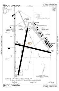
Runways:
| RWY identifier | QFU | Length (ft) | Width (ft) | Surface | LDA (ft) |
| 08 | 104° | 4157 | 150 | ASPH | |
| 26 | 284° | 4157 | 150 | ASPH | |
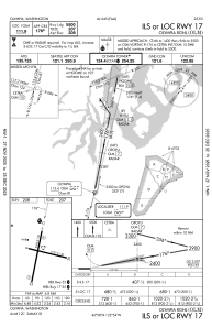
| 17 | 191° | 5500 | 150 | ASPH | |
| 35 | 11° | 5500 | 150 | ASPH |
Airport contact information
Address: Olympia United States
