


KNTU - Oceana Nas (Apollo Soucek Fld)
Located in Virginia Beach, United States
ICAO - NTU, IATA -
Data provided by AirmateGeneral information
Coordinates: N36°49'22" W76°1'55"
Elevation is 22 feet MSL.
Magnetic variation is -10° East View others Airports in Virginia
Operational data
Special qualification required
Current time UTC:
Current local time:
Weather
METAR: KNTU 130056Z 12005KT 10SM FEW080 BKN300 21/17 A3003 RMK AO2 SLP170 T02110172
TAF: TAF KNTU 1223/1323 15008KT 9999 BKN050 BKN250 QNH2998INS TEMPO 1304/1310 VRB04KT 4800 BR BKN050 FM131500 15008KT 9999 SCT050 QNH2999INS TX27/1318Z TN19/1310Z FN20051
Communications frequencies: [VIEW]
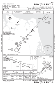
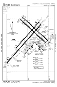
Runways:
| RWY identifier | QFU | Length (ft) | Width (ft) | Surface | LDA (ft) |
| 05L | 42° | 8000 | 150 | OTHER | |
| 23R | 222° | 8000 | 150 | OTHER | |
| 05R | 42° | 12001 | 200 | OTHER | |
| 23L | 222° | 12001 | 200 | OTHER | |
| 14L | 134° | 8001 | 150 | OTHER | |
| 32R | 314° | 8001 | 150 | OTHER | |
| 14R | 134° | 8000 | 200 | OTHER | |
| 32L | 314° | 8000 | 200 | OTHER |
Airport contact information
Address: Virginia Beach United States