


KNSE - Whiting Fld Nas North
Located in Milton, United States
ICAO - NSE, IATA -
Data provided by AirmateGeneral information
Coordinates: N30°43'21" W87°1'26"
Elevation is 199 feet MSL.
Magnetic variation is -02° East View others Airports in Florida
Operational data
Special qualification required
Current time UTC:
Current local time:
Weather
METAR: KNSE 030556Z AUTO 00000KT 9SM BKN085 21/21 A3000 RMK AO2 SLP142 T02110206 10261 20211 402940200 53001 $
TAF: TAF KNSE 0223/0323 21005KT 9999 VCTS FEW010 SCT020CB BKN030 QNH2996INS TEMPO 0223/0302 VRB20G30KT 4800 TSRA SCT010 BKN020CB OVC030 BECMG 0306/0308 VRB04KT 9999 VCSH FEW015 SCT025 BKN040 QNH2997INS BECMG 0318/0320 18008KT 9999 NSW FEW030 SCT050 BKN080 QNH3003INS TX30/0318Z TN19/0309Z FN00275
Communications frequencies: [VIEW]
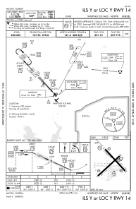
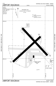
Runways:
| RWY identifier | QFU | Length (ft) | Width (ft) | Surface | LDA (ft) |
| 05 | 47° | 6003 | 200 | ASPH | |
| 23 | 227° | 6003 | 200 | ASPH | |
| 14 | 137° | 6001 | 200 | ASPH | |
| 32 | 317° | 6001 | 200 | ASPH |
Airport contact information
Address: Milton United States