


KMUO - Mountain Home Afb
Located in Mountain Home, United States
ICAO - MUO, IATA -
Data provided by AirmateGeneral information
Coordinates: N43°2'37" W115°52'21"
Elevation is 2996 feet MSL.
Magnetic variation is 13° East View others Airports in Idaho
Operational data
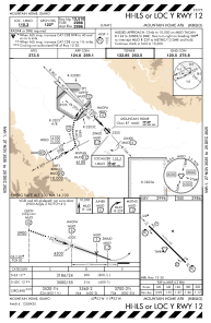
Special qualification required
Current time UTC:
Current local time:
Weather
METAR: KMUO 231255Z 26007KT 7SM SCT050 03/01 A2998 RMK AO2A SLP155 T00260007 $
TAF: TAF AMD KMUO 231255Z 2312/2416 VRB06KT 9999 SCT050 QNH2996INS BECMG 2314/2315 30012G20KT 9999 SCT050 QNH2996INS BECMG 2316/2317 30015G25KT 9999 SCT060 510009 QNH2998INS BECMG 2323/2324 30012G20KT 9999 FEW060 QNH2997INS BECMG 2404/2405 VRB06KT 9999 FEW110 QNH2989INS TX17/2323Z TN02/2313Z
Communications frequencies: [VIEW]
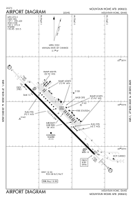
Runways:
| RWY identifier | QFU | Length (ft) | Width (ft) | Surface | LDA (ft) |
| 12 | 135° | 13510 | 200 | OTHER | |
| 30 | 315° | 13510 | 200 | OTHER |
Airport contact information
Address: Mountain Home United States