


KMLU - Monroe Rgnl
Located in Monroe, United States
ICAO - MLU, IATA - MLU
Data provided by AirmateGeneral information
Coordinates: N32°30'38" W92°2'10"
Elevation is 79 feet MSL.
Magnetic variation is 03° East View others Airports in Louisiana
Operational data
Special qualification required
Current time UTC:
Current local time:
Communications frequencies: [VIEW]
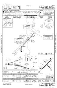
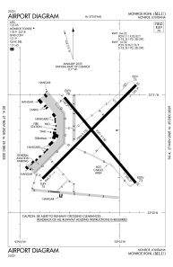
Runways:
| RWY identifier | QFU | Length (ft) | Width (ft) | Surface | LDA (ft) |
| 04 | 45° | 7504 | 150 | ASPH | 7504 |
| 22 | 225° | 7504 | 150 | ASPH | 7504 |
| 14 | 140° | 6301 | 150 | ASPH | 6301 |
| 32 | 320° | 6301 | 150 | ASPH | 6301 |
Airport contact information
Address: Monroe United States