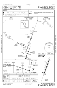
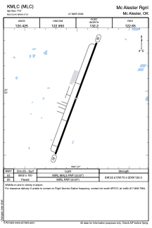


KMLC - Mc Alester Rgnl
Located in Mc Alester, United States
ICAO - MLC, IATA -
Data provided by AirmateGeneral information
Coordinates: N34°52'57" W95°47'0"
Elevation is 770 feet MSL.
Magnetic variation is 02° East View others Airports in Oklahoma
Operational data
Special qualification required
Current time UTC:
Current local time:
Communications frequencies: [VIEW]
Runways:
| RWY identifier | QFU | Length (ft) | Width (ft) | Surface | LDA (ft) |
| 02 | 20° | 5602 | 100 | CONC | |
| 20 | 200° | 5602 | 100 | CONC |
Airport contact information
Address: Mc Alester United States
