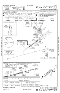
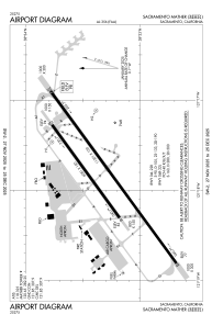


KMHR - Sacramento Mather
Located in Sacramento, United States
ICAO - MHR, IATA - MHR
Data provided by AirmateGeneral information
Coordinates: N38°33'19" W121°17'50"
Elevation is 98 feet MSL.
Magnetic variation is 13° East View others Airports in California
Operational data
Special qualification required
Current time UTC:
Current local time:
Weather
METAR: KMHR 281815Z AUTO VRB06KT 10SM CLR 21/11 A2999 RMK A01
TAF: KMHR 281720Z 2818/2918 17009KT P6SM FEW250 TEMPO 2823/2903 20011G21KT FM291400 34010KT P6SM FEW250
Communications frequencies: [VIEW]
Runways:
| RWY identifier | QFU | Length (ft) | Width (ft) | Surface | LDA (ft) |
| 04L | 54° | 6081 | 150 | ASPH | |
| 22R | 234° | 6081 | 150 | ASPH | |
| 04R | 54° | 11301 | 150 | OTHER | |
| 22L | 234° | 11301 | 150 | OTHER | |
| H1 | 0° | 0 | 0 | UNK | |
| H2 | 0° | 0 | 0 | UNK |
Airport contact information
Address: Sacramento United States
