


KLYH - Lynchburg Rgnl/Preston Glenn Fld
Located in Lynchburg, United States
ICAO - LYH, IATA - LYH
Data provided by AirmateGeneral information
Coordinates: N37°19'31" W79°12'4"
Elevation is 938 feet MSL.
Magnetic variation is -08° East View others Airports in Virginia
Operational data
Special qualification required
Current time UTC:
Current local time:
Weather
METAR: KLYH 052154Z 20011G19KT 10SM SCT039 BKN047 28/19 A2980 RMK AO2 LTG DSNT W SLP081 T02780194
TAF: KLYH 051740Z 0518/0618 18010KT P6SM BKN020 BKN080 FM051900 20011G20KT P6SM VCTS SCT020 BKN035CB TEMPO 0519/0523 VRB15G25KT 2SM TSRA OVC020CB FM060100 21007KT P6SM FEW040 BKN110 BKN250 FM060600 21007KT P6SM BKN030 FM060800 22006KT P6SM OVC008 FM061600 23011G20KT P6SM SCT030 BKN070
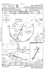
Communications frequencies: [VIEW]
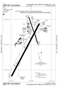
Runways:
| RWY identifier | QFU | Length (ft) | Width (ft) | Surface | LDA (ft) |
| 04 | 28° | 7100 | 150 | ASPH | 6800 |
| 22 | 208° | 7100 | 150 | ASPH | 7100 |
| 17 | 161° | 3386 | 75 | ASPH | 3386 |
| 35 | 341° | 3386 | 75 | ASPH | 3386 |
Airport contact information
Address: Lynchburg United States
