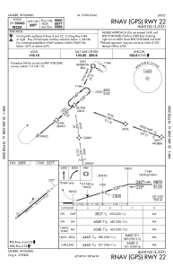
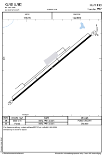


KLND - Hunt Fld
Located in Lander, United States
ICAO - LND, IATA - LND
Data provided by AirmateGeneral information
Coordinates: N42°48'55" W108°43'43"
Elevation is 5588 feet MSL.
Magnetic variation is 10° East View others Airports in Wyoming
Operational data
Special qualification required
Current time UTC:
Current local time:
Communications frequencies: [VIEW]
Runways:
| RWY identifier | QFU | Length (ft) | Width (ft) | Surface | LDA (ft) |
| 04 | 50° | 5000 | 75 | ASPH | |
| 22 | 230° | 5000 | 75 | ASPH |
Airport contact information
Address: Lander United States