


KJLN - Joplin Rgnl
Located in Joplin, United States
ICAO - JLN, IATA - JLN
Data provided by AirmateGeneral information
Coordinates: N37°9'11" W94°29'56"
Elevation is 977 feet MSL.
Magnetic variation is 04° East View others Airports in Missouri
Operational data
Special qualification required
Current time UTC:
Current local time:
Weather
METAR: KJLN 232107Z 17009G17KT 10SM FEW017 SCT043 28/20 A2978 RMK AO2 T02830200
TAF: KJLN 231737Z 2318/2418 19007KT P6SM SCT025 BKN050 FM232300 17010KT P6SM BKN025 PROB30 2404/2410 4SM TSRA BR OVC025CB FM241000 19013G23KT P6SM VCTS BKN015CB FM241400 20012G21KT P6SM BKN015 PROB30 2414/2418 4SM TSRA BR OVC009CB
Communications frequencies: [VIEW]
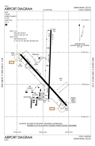
Runways:
| RWY identifier | QFU | Length (ft) | Width (ft) | Surface | LDA (ft) |
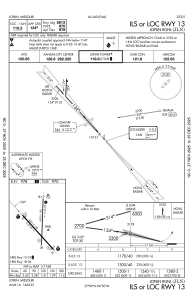
| 13 | 138° | 6501 | 150 | ASPH | 5813 |
| 31 | 318° | 6501 | 150 | ASPH | 5813 |
| 18 | 182° | 6502 | 100 | CONC | 6499 |
| 36 | 2° | 6502 | 100 | CONC | 6499 |
Airport contact information
Address: Joplin United States

