


KIAD - Washington Dulles Intl
Located in Washington, United States
ICAO - IAD, IATA - IAD
Data provided by AirmateGeneral information
Coordinates: N38°56'51" W77°27'36"
Elevation is 312 feet MSL.
Magnetic variation is -10° East View others Airports in District of Columbia
Operational data
Special qualification required
Current time UTC:
Current local time:
Weather
METAR: KIAD 091552Z 26014G25KT 10SM FEW050CB FEW120 BKN150 BKN250 29/16 A2965 RMK AO2 PK WND 29028/1502 SLP037 CB NW MOV SE T02890156 $
TAF: KIAD 091614Z 0916/1018 28012G20KT P6SM VCSH FEW060 BKN250 TEMPO 0916/0918 2SM RA FEW015 BKN040 FM091900 32015G25KT P6SM FEW045 SCT130 FM100000 32008KT P6SM SCT250
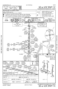
Communications frequencies: [VIEW]
Runways:
| RWY identifier | QFU | Length (ft) | Width (ft) | Surface | LDA (ft) |
| 01C | 1° | 11500 | 150 | CONC | 11500 |
| 19C | 181° | 11500 | 150 | CONC | 11089 |
| 01L | 1° | 9400 | 150 | CONC | 9400 |
| 19R | 181° | 9400 | 150 | CONC | 9400 |
| 01R | 1° | 11500 | 150 | CONC | 11500 |
| 19L | 181° | 11500 | 150 | CONC | 11500 |
| 12 | 111° | 10501 | 150 | CONC | 10501 |
| 30 | 291° | 10501 | 150 | CONC | 10501 |
Airport contact information
Address: Washington United States