


KHUL - Houlton Intl
Located in Houlton, United States
ICAO - HUL, IATA - HUL
Data provided by AirmateGeneral information
Coordinates: N46°7'29" W67°47'32"
Elevation is 489 feet MSL.
Magnetic variation is -18° East View others Airports in Maine
Operational data
Special qualification required
Current time UTC:
Current local time:
Weather
METAR: KHUL 110753Z AUTO 00000KT 7SM BKN039 09/08 A2971 RMK AO2 SLP063 T00940083
TAF: KHUL 110743Z 1108/1206 00000KT 2SM BR SCT090 TEMPO 1108/1111 3SM BR FM111100 00000KT P6SM SCT035 FM111600 00000KT P6SM VCSH BKN040 FM112300 00000KT P6SM BKN060
Communications frequencies: [VIEW]
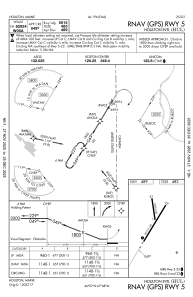
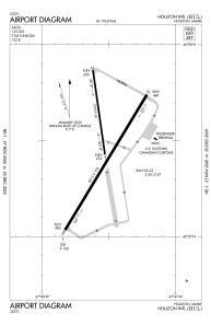
Runways:
| RWY identifier | QFU | Length (ft) | Width (ft) | Surface | LDA (ft) |
| 01 | 352° | 2700 | 60 | ASPH | |
| 19 | 172° | 2700 | 60 | ASPH | |
| 05 | 31° | 5015 | 100 | ASPH | |
| 23 | 211° | 5015 | 100 | ASPH |
Airport contact information
Address: Houlton United States