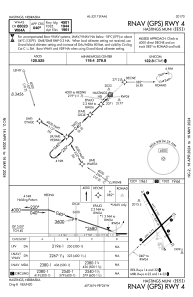
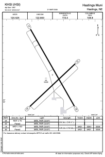


KHSI - Hastings Muni
Located in Hastings, United States
ICAO - HSI, IATA - HSI
Data provided by AirmateGeneral information
Coordinates: N40°36'19" W98°25'40"
Elevation is 1961 feet MSL.
Magnetic variation is 07° East View others Airports in Nebraska
Operational data
Special qualification required
Current time UTC:
Current local time:
Communications frequencies: [VIEW]
Runways:
| RWY identifier | QFU | Length (ft) | Width (ft) | Surface | LDA (ft) |
| 04 | 47° | 4501 | 75 | CONC | |
| 22 | 227° | 4501 | 75 | CONC | |
| 14 | 150° | 6451 | 100 | CONC | 5500 |
| 32 | 330° | 6451 | 100 | CONC | 5500 |
Airport contact information
Address: Hastings United States