


KHRL - Valley Intl
Located in Harlingen, United States
ICAO - HRL, IATA - HRL
Data provided by AirmateGeneral information
Coordinates: N26°13'36" W97°39'19"
Elevation is 36 feet MSL.
Magnetic variation is 03° East View others Airports in Texas
Operational data
Special qualification required
Current time UTC:
Current local time:
Communications frequencies: [VIEW]
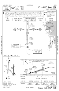
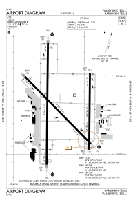
Runways:
| RWY identifier | QFU | Length (ft) | Width (ft) | Surface | LDA (ft) |
| 13 | 136° | 7257 | 150 | ASPH | 7257 |
| 31 | 316° | 7257 | 150 | ASPH | 7257 |
| 18L | 181° | 5950 | 150 | ASPH | 5949 |
| 36R | 1° | 5950 | 150 | ASPH | 5759 |
| 18R | 181° | 9400 | 150 | ASPH | 9400 |
| 36L | 1° | 9400 | 150 | ASPH | 9400 |
Airport contact information
Address: Harlingen United States
