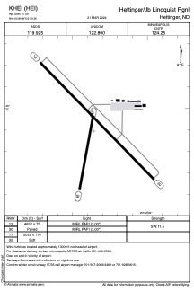


KHEI - Hettinger/Jb Lindquist Rgnl
Located in Hettinger, United States
ICAO - HEI, IATA -
Data provided by AirmateGeneral information
Coordinates: N46°0'54" W102°39'22"
Elevation is 2705 feet MSL.
Magnetic variation is 08° East View others Airports in North Dakota
Operational data
Special qualification required
Current time UTC:
Current local time:
Weather
METAR: KHEI 041053Z AUTO 32011KT 10SM FEW055 SCT080 12/09 A2959 RMK AO2 PK WND 31029/0955 RAB0957E45 SLP007 P0004 T01220089
Communications frequencies: [VIEW]
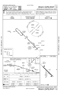
Runways:
| RWY identifier | QFU | Length (ft) | Width (ft) | Surface | LDA (ft) |
| 12 | 136° | 4652 | 75 | ASPH | |
| 30 | 316° | 4652 | 75 | ASPH | |
| 17 | 190° | 2020 | 110 | GRASS | |
| 35 | 10° | 2020 | 110 | GRASS |
Airport contact information
Address: Hettinger United States