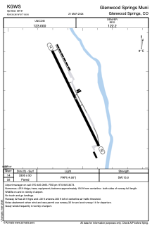


KGWS - Kgws Sumers Airpark
Located in Glenwood Springs, United States
ICAO - GWS, IATA - GWS
Data provided by AirmateGeneral information
Coordinates: N39°30'22" W107°18'33"
Elevation is 5916 feet MSL.
Magnetic variation is 13° East View others Airports in Colorado
Operational data
Special qualification required
Current time UTC:
Current local time:
Communications frequencies: [VIEW]
Runways:
| RWY identifier | QFU | Length (ft) | Width (ft) | Surface | LDA (ft) |
| 14 | 153° | 3305 | 50 | ASPH | |
| 32 | 333° | 3305 | 50 | ASPH |
Airport contact information
Address: Glenwood Springs United States