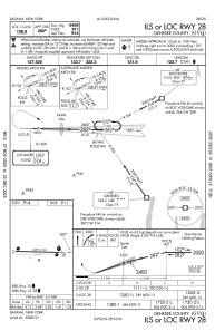
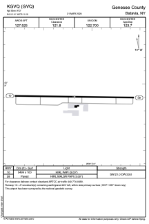


KGVQ - Genesee County
Located in Batavia, United States
ICAO - GVQ, IATA -
Data provided by AirmateGeneral information
Coordinates: N43°1'54" W78°10'11"
Elevation is 913 feet MSL.
Magnetic variation is -11° East View others Airports in New York
Operational data
Special qualification required
Current time UTC:
Current local time:
Weather
METAR: KGVQ 201956Z AUTO 27007KT 10SM BKN060 OVC075 28/16 A2996 RMK AO2 SLP138 T02830161
Communications frequencies: [VIEW]
Runways:
| RWY identifier | QFU | Length (ft) | Width (ft) | Surface | LDA (ft) |
| 10 | 91° | 5499 | 100 | ASPH | |
| 28 | 271° | 5499 | 100 | ASPH |
Airport contact information
Address: Batavia United States
