


KGRR - Gerald R Ford Intl
Located in Grand Rapids, United States
ICAO - GRR, IATA - GRR
Data provided by AirmateGeneral information
Coordinates: N42°52'51" W85°31'22"
Elevation is 793 feet MSL.
Magnetic variation is -06° East View others Airports in Michigan
Operational data
Special qualification required
Current time UTC:
Current local time:
Weather
METAR: KGRR 021853Z VRB05KT 10SM BKN048 BKN250 23/16 A2996 RMK AO2 SLP142 T02330156
TAF: KGRR 021730Z 0218/0318 36005KT P6SM BKN020 FM022000 36005KT P6SM BKN035 FM030200 00000KT P6SM SCT120 FM031200 15006KT P6SM BKN250
Communications frequencies: [VIEW]
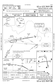
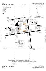
Runways:
| RWY identifier | QFU | Length (ft) | Width (ft) | Surface | LDA (ft) |
| 08L | 81° | 5001 | 100 | ASPH | 5001 |
| 26R | 261° | 5001 | 100 | ASPH | 5001 |
| 08R | 81° | 10001 | 150 | CONC | 10001 |
| 26L | 261° | 10001 | 150 | CONC | 10001 |
| 17 | 171° | 8501 | 150 | CONC | 8501 |
| 35 | 351° | 8501 | 150 | CONC | 8501 |
Airport contact information
Address: Grand Rapids United States
