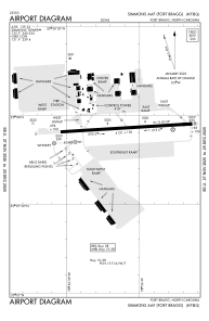


KFBG - Simmons Aaf
Located in Fort Liberty, United States
ICAO - FBG, IATA - FBG
Data provided by AirmateGeneral information
Coordinates: N35°7'56" W78°56'7"
Elevation is 243 feet MSL.
Magnetic variation is -07° East View others Airports in North Carolina
Operational data
Special qualification required
Current time UTC:
Current local time:
Communications frequencies: [VIEW]
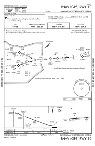
Runways:
| RWY identifier | QFU | Length (ft) | Width (ft) | Surface | LDA (ft) |
| 09 | 86° | 4121 | 100 | ASPH | |
| 27 | 266° | 4121 | 100 | ASPH |
Airport contact information
Address: Fort Liberty United States