


KEAR - Kearney Rgnl
Located in Kearney, United States
ICAO - EAR, IATA - EAR
Data provided by AirmateGeneral information
Coordinates: N40°43'37" W99°0'24"
Elevation is 2131 feet MSL.
Magnetic variation is 05° East View others Airports in Nebraska
Operational data
Special qualification required
Current time UTC:
Current local time:
Communications frequencies: [VIEW]
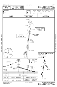
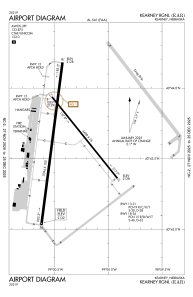
Runways:
| RWY identifier | QFU | Length (ft) | Width (ft) | Surface | LDA (ft) |
| 13 | 141° | 4498 | 75 | CONC | 4498 |
| 31 | 321° | 4498 | 75 | CONC | 4498 |
| 18 | 187° | 7094 | 100 | CONC | 7094 |
| 36 | 7° | 7094 | 100 | CONC | 7094 |
Airport contact information
Address: Kearney United States
