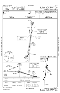
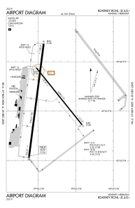


KEAR - Kearney Rgnl
Located in Kearney, United States
ICAO - EAR, IATA - EAR
Data provided by AirmateGeneral information
Coordinates: N40°43'37" W99°0'24"
Elevation is 2131 feet MSL.
Magnetic variation is 05° East View others Airports in Nebraska
Operational data
Special qualification required
Current time UTC:
Current local time:
Weather
METAR: KEAR 041256Z AUTO 18010KT 10SM BKN120 18/17 A2967 RMK AO2 SLP029 T01830167
TAF: KEAR 041120Z 0412/0512 22005KT P6SM VCSH SCT070 BKN130 FM041500 24010KT P6SM VCSH SCT050 OVC100 FM041800 29010G15KT P6SM SCT060 OVC100 FM042000 33013G21KT P6SM VCTS SCT060CB BKN090 FM050100 01009KT P6SM FEW230 FM050700 VRB05KT P6SM SKC
Communications frequencies: [VIEW]
Runways:
| RWY identifier | QFU | Length (ft) | Width (ft) | Surface | LDA (ft) |
| 13 | 141° | 4498 | 75 | CONC | 4498 |
| 31 | 321° | 4498 | 75 | CONC | 4498 |
| 18 | 187° | 7094 | 100 | CONC | 7094 |
| 36 | 7° | 7094 | 100 | CONC | 7094 |
Airport contact information
Address: Kearney United States
