


KDYS - Dyess Afb
Located in Abilene, United States
ICAO - DYS, IATA - DYS
Data provided by AirmateGeneral information
Coordinates: N32°25'7" W99°51'24"
Elevation is 1790 feet MSL.
Magnetic variation is 05° East View others Airports in Texas
Operational data
Special qualification required
Current time UTC:
Current local time:
Weather
TAF: TAF KDYS 281600Z 2816/2922 09025G35KT 9999 BKN040 QNH2991INS BECMG 2820/2821 VRB40G50KT 4800 TSRAGR BKN020CB QNH2991INS BECMG 2905/2906 14025G35KT 6000 RA VCTS BKN010CB QNH2994INS BECMG 2909/2910 10012G18KT 9000 -SHRA BKN005 QNH2995INS BECMG 2912/2913 11015G25KT 9000 -SHRA VCTS BKN005CB QNH2999INS BECMG 2913/2914 VRB25G35KT 6000 TSRA BKN005CB QNH2999INS BECMG 2915/2916 11015G25KT 8000 -RA VCTS BKN015CB QNH3000INS BECMG 2916/2917 11012G18KT 9999 NSW BKN020 QNH2988INS TX30/2821Z TN22/2911Z
Communications frequencies: [VIEW]
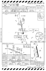
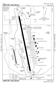
Runways:
| RWY identifier | QFU | Length (ft) | Width (ft) | Surface | LDA (ft) |
| 16 | 0° | 13500 | 300 | OTHER | |
| 34 | 0° | 13500 | 300 | OTHER | |
| 163 | 0° | 3500 | 60 | OTHER | |
| 343 | 0° | 3500 | 60 | OTHER | |
| 164 | 0° | 3498 | 60 | ASPH | |
| 344 | 0° | 3498 | 60 | ASPH |
Airport contact information
Address: Abilene United States