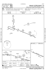


KDNA - Dona Ana County Intl Jetport
Located in Santa Teresa, United States
ICAO - DNA, IATA -
Data provided by AirmateGeneral information
Coordinates: N31°52'50" W106°42'12"
Elevation is 4112 feet MSL.
Magnetic variation is 11° East View others Airports in New Mexico
Operational data
Special qualification required
Current time UTC:
Current local time:
Communications frequencies: [VIEW]
Runways:
| RWY identifier | QFU | Length (ft) | Width (ft) | Surface | LDA (ft) |
| 10 | 112° | 9550 | 100 | ASPH | |
| 28 | 292° | 9550 | 100 | ASPH |
Airport contact information
Address: Santa Teresa United States