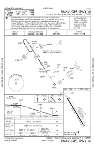
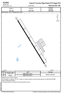


KDMW - Carroll County Rgnl/Jack B Poage Fld
Located in Westminster, United States
ICAO - DMW, IATA -
Data provided by AirmateGeneral information
Coordinates: N39°36'30" W77°0'28"
Elevation is 789 feet MSL.
Magnetic variation is -11° East View others Airports in Maryland
Operational data
Special qualification required
Current time UTC:
Current local time:
Weather
METAR: KDMW 032245Z AUTO 00000KT 10SM CLR 29/14 A2992 RMK AO2
Communications frequencies: [VIEW]
Runways:
| RWY identifier | QFU | Length (ft) | Width (ft) | Surface | LDA (ft) |
| 16 | 148° | 5100 | 100 | ASPH | |
| 34 | 328° | 5100 | 100 | ASPH |
Airport contact information
Address: Westminster United States

