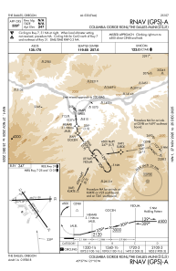
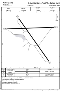


KDLS - Columbia Gorge Rgnl/The Dalles Muni
Located in The Dalles, United States
ICAO - DLS, IATA - DLS
Data provided by AirmateGeneral information
Coordinates: N45°37'10" W121°10'6"
Elevation is 246 feet MSL.
Magnetic variation is 15° East View others Airports in Oregon
Operational data
Special qualification required
Current time UTC:
Current local time:
Communications frequencies: [VIEW]
Runways:
| RWY identifier | QFU | Length (ft) | Width (ft) | Surface | LDA (ft) |
| 07 | 88° | 4647 | 100 | ASPH | |
| 25 | 268° | 4647 | 100 | ASPH | |
| 13 | 145° | 5097 | 100 | ASPH | |
| 31 | 325° | 5097 | 100 | ASPH |
Airport contact information
Address: The Dalles United States
Other aviation service providers
Flight schools

Gorge Aviation Services, Llc
Gorge Aviation Services, Llc
rolf@gorgeaviationservices.com+1(509)767-0005