logo
Search for airport 
image banner adimage banner adimage banner ad
image banner ad

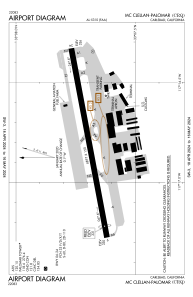
KCRQ - Mc Clellan-Palomar

Located in Carlsbad, United States

ICAO - CRQ, IATA - CLD

Data provided by Airmate  

General information

Coordinates: N33°7'42" W117°16'48"
Elevation is 330 feet MSL.
Magnetic variation is 14° East
View others Airports in California

Operational data

Special qualification required
Current time UTC:
Current local time:
Weather
METAR: KCRQ 281953Z VRB03KT 10SM OVC010 16/13 A3005 RMK AO2 SLP175 T01610128 $
TAF: KCRQ 281926Z 2819/2918 25008KT P6SM OVC010 FM282100 25008KT P6SM SCT012 TEMPO 2823/2902 BKN010 FM290200 VRB04KT P6SM OVC009 FM290500 VRB04KT 3SM BR OVC006 FM291600 22004KT P6SM OVC009
View NOTAMs / SUP AIP / TFR affecting this airport [VIEW]
Communications frequencies: [VIEW]

Runways:

RWY identifierQFULength (ft)Width (ft)SurfaceLDA (ft)
0679°4897150ASPH4600
24259°4897150ASPH4897
H100UNK

Airport contact information

Address: Carlsbad United States

Other aviation service providers

Repair station

Hangar One Avionics Inc.

Hangar One Avionics Inc.

Flight schools

Pinnacle Aviation Academy

Pinnacle Aviation Academy

Civic Helicopters, Inc.

Civic Helicopters, Inc.

Pacific Coast Flyers

Pacific Coast Flyers
info@pcflyers.org+1(760)845-9713

Loft

Loft
info@loft.aero+1(760)476-0890

Plus One Flyers - Crq

Plus One Flyers - Crq

Atp Flight School (800-All-Atps)

Atp Flight School (800-All-Atps)
info@allatps.com+1(800)255-2877

Blade & Wing Aviation

Blade & Wing Aviation

Satellite view of KCRQ