


KCMA - Camarillo
Located in Camarillo, United States
ICAO - CMA, IATA -
Data provided by AirmateGeneral information
Coordinates: N34°12'50" W119°5'40"
Elevation is 76 feet MSL.
Magnetic variation is 14° East View others Airports in California
Operational data
Special qualification required
Current time UTC:
Current local time:
Communications frequencies: [VIEW]
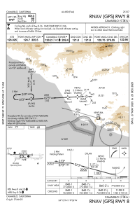
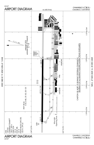
Runways:
| RWY identifier | QFU | Length (ft) | Width (ft) | Surface | LDA (ft) |
| 08 | 90° | 6013 | 150 | OTHER | |
| 26 | 270° | 6013 | 150 | OTHER | |
| H1 | 0° | 0 | 0 | UNK | |
| H2 | 0° | 0 | 0 | UNK |
Airport contact information
Address: Camarillo United States
Other aviation service providers
Repair station

Flight schools

Atp Flight School (800-All-Atps)
Atp Flight School (800-All-Atps)
info@atpflightschool.com+1(800)255-2877