


KCGI - Cape Girardeau Rgnl
Located in Cape Girardeau, United States
ICAO - CGI, IATA - CGI
Data provided by AirmateGeneral information
Coordinates: N37°13'31" W89°34'15"
Elevation is 341 feet MSL.
Magnetic variation is -02° East View others Airports in Missouri
Operational data
Special qualification required
Current time UTC:
Current local time:
Weather
METAR: KCGI 231653Z 12004KT 10SM BKN110 21/19 A2992 RMK AO2 LTG DSNT NE RAE32 TSE09 SLP128 P0003 T02060194
TAF: KCGI 231521Z 2315/2412 14005KT P6SM VCSH OVC004 TEMPO 2315/2317 OVC012 FM231700 19007KT P6SM VCTS OVC025CB FM232000 20007KT P6SM OVC035 FM240100 17005KT P6SM SCT250
Communications frequencies: [VIEW]
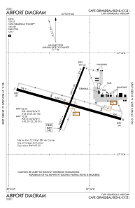
Runways:
| RWY identifier | QFU | Length (ft) | Width (ft) | Surface | LDA (ft) |
| 02 | 21° | 3997 | 100 | OTHER | 3997 |
| 20 | 201° | 3997 | 100 | OTHER | 3997 |
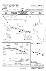
| 10 | 106° | 6500 | 150 | CONC | 6500 |
| 28 | 286° | 6500 | 150 | CONC | 6500 |
Airport contact information
Address: Cape Girardeau United States

