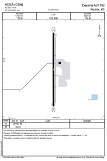


KCEA - Cessna Acft Fld
Located in Wichita, United States
ICAO - CEA, IATA - CEA
Data provided by AirmateGeneral information
Coordinates: N37°38'55" W97°15'2"
Elevation is 1378 feet MSL.
Magnetic variation is 08° East View others Airports in Kansas
Operational data
Special qualification required
Current time UTC:
Current local time:
Weather at : KIAB - Mc Connell Afb ( 3 km )
METAR: KIAB 031055Z AUTO 09003KT 10SM SCT032 19/18 A2976 RMK AO2 LTG DSNT SE-S SLP069 T01890176
TAF: TAF KIAB 031000Z 0310/0416 18009KT 8000 -SHRA VCTS SCT040 BKN090CB QNH2976INS TEMPO 0310/0316 VRB20G30KT 4800 -TSRA BKN040CB BECMG 0317/0318 07006KT 9999 NSW SCT055 BKN120 QNH2962INS BECMG 0412/0413 22010G15KT 8000 -SHRA BKN008 OVC025 QNH2961INS TX28/0321Z TN21/0312Z
Communications frequencies: [VIEW]
Runways:
| RWY identifier | QFU | Length (ft) | Width (ft) | Surface | LDA (ft) |
| 17 | 180° | 3873 | 40 | ASPH | |
| 35 | 0° | 3873 | 40 | ASPH |
Airport contact information
Address: Wichita United States