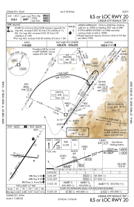
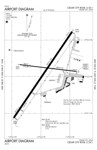


KCDC - Cedar City Rgnl
Located in Cedar City, United States
ICAO - CDC, IATA - CDC
Data provided by AirmateGeneral information
Coordinates: N37°42'3" W113°5'56"
Elevation is 5622 feet MSL.
Magnetic variation is 14° East View others Airports in Utah
Operational data
Special qualification required
Current time UTC:
Current local time:
Communications frequencies: [VIEW]
Runways:
| RWY identifier | QFU | Length (ft) | Width (ft) | Surface | LDA (ft) |
| 02 | 34° | 8653 | 150 | ASPH | 8653 |
| 20 | 214° | 8653 | 150 | ASPH | 8653 |
| 08 | 97° | 4822 | 60 | ASPH | 4822 |
| 26 | 277° | 4822 | 60 | ASPH | 4822 |
Airport contact information
Address: Cedar City United States
