


KCAK - Akron-Canton Rgnl
Located in Akron, United States
ICAO - CAK, IATA - CAK
Data provided by AirmateGeneral information
Coordinates: N40°54'54" W81°26'37"
Elevation is 1225 feet MSL.
Magnetic variation is -07° East View others Airports in Ohio
Operational data
Special qualification required
Current time UTC:
Current local time:
Weather
METAR: KCAK 011751Z 15008KT 10SM SCT250 23/09 A3016 RMK AO2 SLP209 T02330089 10239 20133 58017 $
TAF: KCAK 011741Z 0118/0218 16008KT P6SM BKN250 FM021100 23007KT P6SM -SHRA OVC035 FM021300 18008KT 5SM -SHRA BR OVC015 TEMPO 0213/0216 4SM -RA BR OVC009
Communications frequencies: [VIEW]
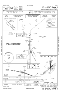
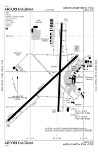
Runways:
| RWY identifier | QFU | Length (ft) | Width (ft) | Surface | LDA (ft) |
| 01 | 2° | 7601 | 150 | ASPH | 7007 |
| 19 | 182° | 7601 | 150 | ASPH | 7007 |
| 05 | 47° | 8204 | 150 | ASPH | 8204 |
| 23 | 227° | 8204 | 150 | ASPH | 8204 |
Airport contact information
Address: Akron United States
