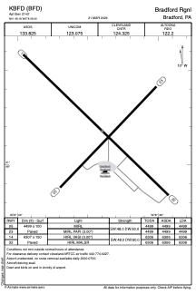


KBFD - Bradford Rgnl
Located in Bradford, United States
ICAO - BFD, IATA - BFD
Data provided by AirmateGeneral information
Coordinates: N41°48'11" W78°38'24"
Elevation is 2143 feet MSL.
Magnetic variation is -11° East View others Airports in Pennsylvania
Operational data
Special qualification required
Current time UTC:
Current local time:
Communications frequencies: [VIEW]
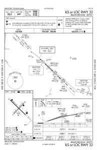
Runways:
| RWY identifier | QFU | Length (ft) | Width (ft) | Surface | LDA (ft) |
| 05 | 44° | 4499 | 100 | ASPH | 4499 |
| 23 | 224° | 4499 | 100 | ASPH | 4499 |
| 14 | 134° | 6307 | 150 | ASPH | 6306 |
| 32 | 314° | 6307 | 150 | ASPH | 6306 |
Airport contact information
Address: Bradford United States
