


KBBG - Branson
Located in Branson, United States
ICAO - BBG, IATA -
Data provided by AirmateGeneral information
Coordinates: N36°31'55" W93°12'2"
Elevation is 1302 feet MSL.
Magnetic variation is 02° East View others Airports in Missouri
Operational data
Special qualification required
Current time UTC:
Current local time:
Weather
METAR: KBBG 040255Z AUTO 14007KT 10SM BKN010 18/18 A2975 RMK AO2 TSNO
TAF: KBBG 040254Z 0403/0424 14004KT P6SM BKN230 PROB30 0409/0412 4SM TSRA BR OVC025CB FM041200 VRB04KT P6SM BKN035 PROB30 0413/0415 4SM TSRA BR OVC025CB FM041600 17007KT P6SM SCT160
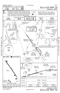
Communications frequencies: [VIEW]
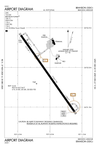
Runways:
| RWY identifier | QFU | Length (ft) | Width (ft) | Surface | LDA (ft) |
| 14 | 145° | 7140 | 150 | CONC | 7140 |
| 32 | 325° | 7140 | 150 | CONC | 7140 |
Airport contact information
Address: Branson United States