


KADW - Joint Base Andrews
Located in Camp Springs, United States
ICAO - ADW, IATA - ADW
Data provided by AirmateGeneral information
Coordinates: N38°48'39" W76°52'1"
Elevation is 279 feet MSL.
Magnetic variation is -10° East View others Airports in Maryland
Operational data
Special qualification required
Current time UTC:
Current local time:
Weather
TAF: TAF AMD KADW 282150Z 2821/2923 29010KT 9999 BKN050 QNH2982INS TEMPO 2821/2823 30012G25KT 9000 -SHRA VCTS SCT040CB BECMG 2823/2824 29008KT 9999 FEW060 QNH2984INS BECMG 2904/2905 32005KT 9999 SKC QNH2988INS BECMG 2912/2913 31004KT 9999 SCT030 QNH2994INS BECMG 2916/2917 27004KT 9999 VCSH BKN040 BKN120 QNH2990INS BECMG 2918/2919 28010KT 8000 -SHRA VCTS FEW030CB BKN040 BKN120 BKN250 QNH2990INS TEMPO 2919/2923 27015G30KT 4800 TSRA BKN030CB OVC080 TX23/2920Z TN15/2910Z
Communications frequencies: [VIEW]
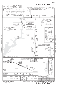
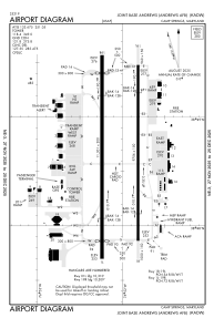
Runways:
| RWY identifier | QFU | Length (ft) | Width (ft) | Surface | LDA (ft) |
| 01L | 360° | 9318 | 200 | CONC | |
| 19R | 180° | 9318 | 200 | CONC | |
| 01R | 360° | 9756 | 150 | OTHER | |
| 19L | 180° | 9756 | 150 | OTHER |
Airport contact information
Address: Camp Springs United States