


K63 - Council Grove Muni
Located in Council Grove, United States
ICAO - K63, IATA -
Data provided by AirmateGeneral information
Coordinates: N38°40'35" W96°34'22"
Elevation is 1409 feet MSL.
Magnetic variation is 06° East View others Airports in Kansas
Operational data
Special qualification required
Current time UTC:
Current local time:
Weather at : KFRI - Marshall Aaf ( 45 km )
METAR: KFRI 290455Z AUTO 00000KT 10SM CLR 17/16 A3011 RMK AO2 SLP188 T01740156 402840123 PNO $
TAF: TAF KFRI 290400Z 2904/3010 VRB05KT 9999 BKN080 QNH3015INS BECMG 2912/2913 13010G20KT 9000 -SHRA BKN090 QNH3019INS BECMG 2917/2918 15010G15KT 9999 NSW BKN090 QNH3007INS BECMG 2923/2924 14009KT 9999 FEW150 QNH3006INS TX27/2922Z TN16/2910Z
Communications frequencies: [VIEW]
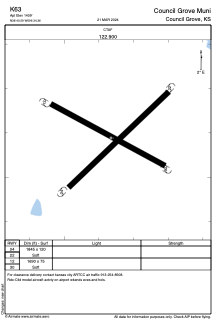
Runways:
| RWY identifier | QFU | Length (ft) | Width (ft) | Surface | LDA (ft) |
| 04 | 0° | 1845 | 120 | GRASS | |
| 22 | 0° | 1845 | 120 | GRASS | |
| 12 | 0° | 1690 | 75 | GRASS | |
| 30 | 0° | 1690 | 75 | GRASS |
Airport contact information
Address: Council Grove United States