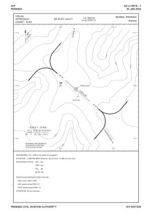


HRYN - Nemba
Located in Nyamata, Rwanda
ICAO - HRYN, IATA -
Data provided by AirmateGeneral information
Coordinates: S2°20'0" E30°12'0"
Elevation is 4905 feet MSL.
View others Airports in East
Operational data
Special qualification required
Current time UTC:
Current local time:
Communications frequencies: [VIEW]
Runways:
| RWY identifier | QFU | Length (ft) | Width (ft) | Surface | LDA (ft) |
| 13 | 131° | 3609 | 82 | UNK | |
| 31 | 311° | 3609 | 82 | UNK |
Airport contact information
Address: Nyamata Rwanda