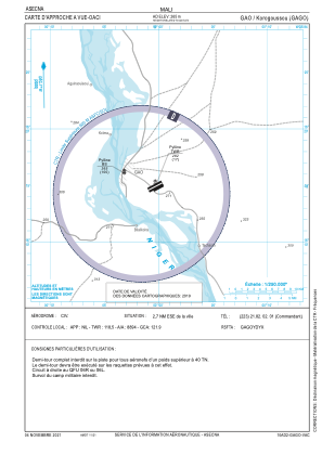


GAGO - Gao/Korogoussou
Located in Gao, Mali
ICAO - GAGO, IATA - GAQ
Data provided by AirmateGeneral information
Coordinates: N16°14'54" W0°0'21"
Elevation is 870 feet MSL.
View others Airports in Gao
Operational data
Special qualification required
Current time UTC:
Current local time:
Communications frequencies: [VIEW]
Runways:
| RWY identifier | QFU | Length (ft) | Width (ft) | Surface | LDA (ft) |
| 06L | 63° | 8202 | 148 | UNK | |
| 24R | 243° | 8202 | 148 | UNK | |
| 06R | 63° | 5906 | 98 | UNK | |
| 24L | 243° | 5906 | 98 | UNK |
Airport contact information
Address: Gao Mali