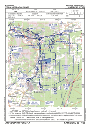
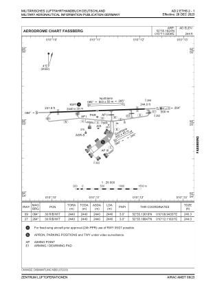


ETHS - Fassberg
Located in Fassberg, Germany
ICAO - ETHS, IATA -
Data provided by AirmateGeneral information
Coordinates: N52°55'10" E10°11'2"
Elevation is 244 feet MSL.
Magnetic variation is 4.21° East View others Airports in Lower Saxony
Operational data
Special qualification required
Current time UTC:
Current local time:
Communications frequencies: [VIEW]
Runways:
| RWY identifier | QFU | Length (ft) | Width (ft) | Surface | LDA (ft) |
| 09 | 88° | 8005 | 98 | CONC+ASPH | 8005 |
| 27 | 268° | 8005 | 98 | CONC+ASPH | 8005 |
Airport contact information
Address: Fassberg Germany
