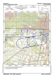
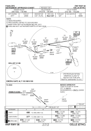
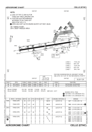


ETHC - Celle
Located in Celle, Germany
ICAO - ETHC, IATA - ZCN
Data provided by AirmateGeneral information
Coordinates: N52°35'28" E10°1'20"
Elevation is 129 feet MSL.
Magnetic variation is 4.14° East View others Airports in Lower Saxony
Operational data
Special qualification required
Current time UTC:
Current local time:
Communications frequencies: [VIEW]
Runways:
| RWY identifier | QFU | Length (ft) | Width (ft) | Surface | LDA (ft) |
| 08 | 81° | 6006 | 148 | ASPH | 6006 |
| 26 | 261° | 6006 | 148 | ASPH | 6006 |
Airport contact information
Address: Celle Germany