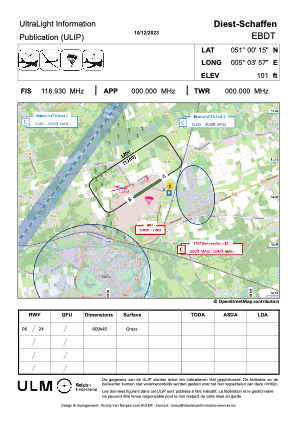


EBDT - Diest / Schaffen
Located in Diest, Belgium
ICAO - EBDT, IATA -
Data provided by AirmateGeneral information
Coordinates: N51°0'5" E5°3'43"
Elevation is 92 feet MSL.
View others Airports in Flemish Brabant
Operational data
Special qualification required
Current time UTC:
Current local time:
Communications frequencies: [VIEW]
Runways:
| RWY identifier | QFU | Length (ft) | Width (ft) | Surface | LDA (ft) |
| 06 | 0° | 1969 | 98 | GRASS | |
| 24 | 0° | 1969 | 98 | GRASS |
Airport contact information
Address: Diest Belgium