


E89 - Conchas Lake
Located in Conchas Dam, United States
ICAO - E89, IATA -
Data provided by AirmateGeneral information
Coordinates: N35°22'4" W104°10'50"
Elevation is 4232 feet MSL.
Magnetic variation is 10° East View others Airports in New Mexico
Operational data
Special qualification required
Current time UTC:
Current local time:
Weather at : KTCC - Tucumcari Muni ( 56 km )
TAF: KTCC 281720Z 2818/2918 11008KT P6SM SKC FM282100 12012G21KT P6SM SCT120 FM290300 09024G33KT P6SM SCT020 FM290600 07014G20KT P6SM BKN015 FM290800 04008KT P6SM OVC015 FM291700 20007KT P6SM SCT030 SCT250
Communications frequencies: [VIEW]
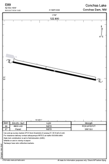
Runways:
| RWY identifier | QFU | Length (ft) | Width (ft) | Surface | LDA (ft) |
| 09 | 0° | 4800 | 60 | ASPH | |
| 27 | 0° | 4800 | 60 | ASPH |
Airport contact information
Address: Conchas Dam United States