


CYQD - The Pas
Located in , Canada
ICAO - CYQD, IATA - YQD
Data provided by AirmateGeneral information
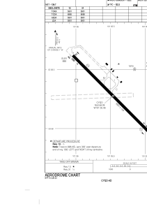
Coordinates: N53°58'17" W101°5'28"
Elevation is 888 feet MSL.
Magnetic variation is 6.1211° East View others Airports in Manitoba
Operational data
Special qualification required
Current time UTC:
Current local time:
Weather
METAR: CYQD 142300Z AUTO 16004KT 140V200 9SM BKN076 BKN180 21/11 A2984 RMK SLP112 DENSITY ALT 1900FT
TAF: TAF CYQD 141840Z 1419/1507 16007KT P6SM BKN060 TEMPO 1419/1505 P6SM -SHRA OVC040 BECMG 1501/1503 VRB03KT FM150500 VRB03KT P6SM SCT110 TEMPO 1505/1507 BKN100 RMK FCST BASED ON AUTO OBS. NXT FCST BY 150100Z
Communications frequencies: [VIEW]
Runways:
| RWY identifier | QFU | Length (ft) | Width (ft) | Surface | LDA (ft) |
| 13 | 135° | 5901 | 150 | ASPH | 5901 |
| 31 | 315° | 5901 | 150 | ASPH | 5901 |
Airport contact information
Address: Canada