


CYDF - Deer Lake
Located in , Canada
ICAO - CYDF, IATA - YDF
Data provided by AirmateGeneral information
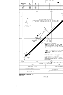
Coordinates: N49°12'33" W57°23'40"
Elevation is 72 feet MSL.
Magnetic variation is -19.97° East View others Airports in Newfoundland and Labrador
Operational data
Special qualification required
Current time UTC:
Current local time:
Weather
METAR: CYDF 040800Z 03009KT 15SM OVC007 09/08 A3006 RMK ST8 SLP183
TAF: TAF CYDF 040740Z 0408/0508 03005KT P6SM OVC008 TEMPO 0408/0412 OVC015 PROB30 0408/0412 2SM -DZ BR OVC005 FM041200 04010G20KT P6SM SCT008 OVC015 TEMPO 0412/0416 BKN008 OVC015 FM041600 04012G22KT P6SM BKN015 BKN025 TEMPO 0416/0422 SCT015 BKN025 FM042200 04012G22KT P6SM -SHRA BKN008 OVC015 FM050300 04012G22KT 6SM -RA BR OVC007 RMK NXT FCST BY 041400Z
Communications frequencies: [VIEW]
Runways:
| RWY identifier | QFU | Length (ft) | Width (ft) | Surface | LDA (ft) |
| 07 | 46° | 8005 | 150 | ASPH | 8005 |
| 25 | 226° | 8005 | 150 | ASPH | 8005 |
Airport contact information
Address: Canada