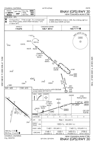
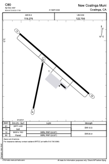


C80 - New Coalinga Muni
Located in Coalinga, United States
ICAO - C80, IATA -
Data provided by AirmateGeneral information
Coordinates: N36°9'44" W120°17'41"
Elevation is 625 feet MSL.
Magnetic variation is 15° East View others Airports in California
Operational data
Special qualification required
Current time UTC:
Current local time:
Communications frequencies: [VIEW]
Runways:
| RWY identifier | QFU | Length (ft) | Width (ft) | Surface | LDA (ft) |
| 01 | 12° | 2471 | 60 | OTHER | |
| 19 | 192° | 2471 | 60 | OTHER | |
| 12 | 131° | 5000 | 100 | ASPH | |
| 30 | 311° | 5000 | 100 | ASPH | |
| H1 | 0° | 0 | 0 | UNK |
Airport contact information
Address: Coalinga United States