
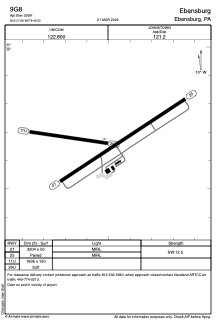


9G8 - Ebensburg
Located in Ebensburg, United States
ICAO - 9G8, IATA -
Data provided by AirmateGeneral information
Coordinates: N40°27'41" W78°46'31"
Elevation is 2099 feet MSL.
Magnetic variation is -09° East View others Airports in Pennsylvania
Operational data
Special qualification required
Current time UTC:
Current local time:
Communications frequencies: [VIEW]
Runways:
| RWY identifier | QFU | Length (ft) | Width (ft) | Surface | LDA (ft) |
| 07 | 57° | 3204 | 50 | ASPH | |
| 25 | 237° | 3204 | 50 | ASPH | |
| 11U | 98° | 1636 | 150 | OTHER | |
| 29U | 278° | 1636 | 150 | OTHER | |
| 11 | 0° | 0 | 0 | UNK | |
| 29 | 0° | 0 | 0 | UNK |
Airport contact information
Address: Ebensburg United States