


92C - Carter
Located in Pulaski, United States
ICAO - 92C, IATA -
Data provided by AirmateGeneral information
Coordinates: N44°38'28" W88°12'55"
Elevation is 783 feet MSL.
Magnetic variation is -02° East View others Airports in Wisconsin
Operational data
Special qualification required
Current time UTC:
Current local time:
Weather at : KGRB - Green Bay/Austin Straubel Intl ( 19 km )
METAR: KGRB 161853Z 18012KT 10SM BKN030 BKN110 24/19 A2981 RMK AO2 SLP090 T02390189
TAF: KGRB 161746Z 1618/1718 18012KT P6SM BKN035 FM161900 19009G19KT P6SM SCT050 BKN120 FM170400 20008G15KT P6SM SCT200 WS020/24030KT FM170600 20008G15KT P6SM -SHRA SCT035 OVC080 TEMPO 1706/1709 2SM TSRA BKN035CB FM171000 22007KT P6SM BKN060
Communications frequencies: [VIEW]
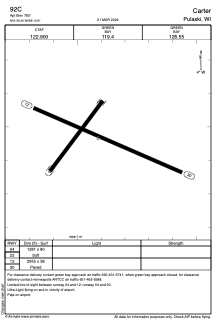
Runways:
| RWY identifier | QFU | Length (ft) | Width (ft) | Surface | LDA (ft) |
| 04 | 0° | 1281 | 80 | GRASS | |
| 22 | 0° | 1281 | 80 | GRASS | |
| 12 | 114° | 2955 | 38 | ASPH | |
| 30 | 294° | 2955 | 38 | ASPH |
Airport contact information
Address: Pulaski United States