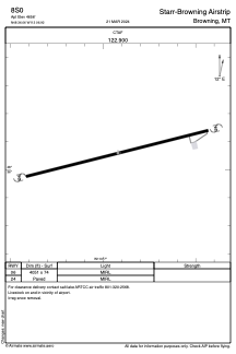


8S0 - Starr-Browning Airstrip
Located in Browning, United States
ICAO - 8S0, IATA -
Data provided by AirmateGeneral information
Coordinates: N48°36'4" W113°6'55"
Elevation is 4657 feet MSL.
Magnetic variation is 18° East View others Airports in Montana
Operational data
Special qualification required
Current time UTC:
Current local time:
Weather at : KCTB - Cut Bank Intl ( 54 km )
METAR: KCTB 231556Z AUTO 34008KT 10SM BKN036 BKN043 09/02 A2993 RMK AO2 SLP140 T00890017 /
TAF: KCTB 231120Z 2312/2412 34008KT P6SM FEW040 FM232300 35007KT P6SM BKN040 PROB30 2323/2401 6SM -SHRA OVC030 FM240200 VRB05KT P6SM OVC030 PROB30 2402/2407 6SM -SHRA
Communications frequencies: [VIEW]
Runways:
| RWY identifier | QFU | Length (ft) | Width (ft) | Surface | LDA (ft) |
| 06 | 0° | 4051 | 74 | ASPH | |
| 24 | 0° | 4051 | 74 | ASPH |
Airport contact information
Address: Browning United States