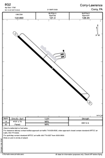


8G2 - Corry-Lawrence
Located in Corry, United States
ICAO - 8G2, IATA -
Data provided by AirmateGeneral information
Coordinates: N41°54'27" W79°38'28"
Elevation is 1766 feet MSL.
Magnetic variation is -10° East View others Airports in Pennsylvania
Operational data
Special qualification required
Current time UTC:
Current local time:
Communications frequencies: [VIEW]
Runways:
| RWY identifier | QFU | Length (ft) | Width (ft) | Surface | LDA (ft) |
| 14 | 133° | 4101 | 75 | ASPH | |
| 32 | 313° | 4101 | 75 | ASPH |
Airport contact information
Address: Corry United States