


7KS4 - Bent Nail Ranch
Located in Horton, United States
ICAO - 7KS4, IATA -
Data provided by AirmateGeneral information
Coordinates: N39°37'59" W95°26'22"
Elevation is 1124 feet MSL.
Magnetic variation is 05° East View others Airports in Kansas
Operational data
Special qualification required
Current time UTC:
Current local time:
Communications frequencies: [VIEW]
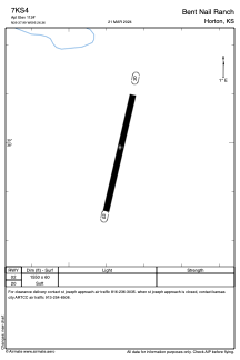
Runways:
| RWY identifier | QFU | Length (ft) | Width (ft) | Surface | LDA (ft) |
| 02 | 0° | 1550 | 60 | GRASS | |
| 20 | 0° | 1550 | 60 | GRASS |
Airport contact information
Address: Horton United States