


51K - Cedar Air Park
Located in Olathe, United States
ICAO - 51K, IATA -
Data provided by AirmateGeneral information
Coordinates: N38°55'52" W94°53'5"
Elevation is 1024 feet MSL.
Magnetic variation is 05° East View others Airports in Kansas
Operational data
Special qualification required
Current time UTC:
Current local time:
Weather at : KIXD - New Century Aircenter ( 11 km )
METAR: KIXD 080853Z AUTO 12010KT 10SM FEW019 21/17 A2979 RMK AO2 PK WND 13027/0812 RAE30 SLP074 P0011 60048 T02060172 58007
TAF: KIXD 080726Z 0807/0906 VRB20G30KT 5SM -RA VCTS BKN035 BKN100CB TEMPO 0807/0808 2SM TSRA BR BKN035CB FM080900 10012KT P6SM VCSH BKN035 FM081100 15006KT P6SM BKN020 FM081700 19005KT P6SM SCT040 FM082200 02012KT P6SM SCT120 FM090000 04005KT P6SM SCT120
Communications frequencies: [VIEW]
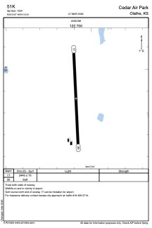
Runways:
| RWY identifier | QFU | Length (ft) | Width (ft) | Surface | LDA (ft) |
| 17 | 177° | 2440 | 75 | GRASS | |
| 35 | 357° | 2440 | 75 | GRASS |
Airport contact information
Address: Olathe United States